


Trinity County Wildfire Mitigation Project


The McConnell Foundation has been awarded a large grant from FEMA and Cal OES to mitigate wildfire impacts around the communities of Weaverville, Covington Mill, and Trinity Center. Trinity County Resource Conservation District is steering the implementation of this project.
Hazardous fuel reduction will be provided at no cost to eligible landowners. The registration deadline has now passed.
The goal of the Project is to reduce risk of wildfire along certain critical corridors within high-priority wildland urban interface (WUI) areas by reducing hazardous fuels. The first phase of the Project requires a preliminary site assessment to determine the potential boundaries of the Project area. Site assessments will determine where fuel treatments can take place and will take into consideration environmental constraints, topography, fuel types, and fuel loading relative to beneficial outcomes. The McConnell Foundation and Trinity County Resource Conservation District may wish to enter onto your land as part of that preliminary site assessment to determine the locations and extent of the proposed fuel reduction treatments, if any, to be conducted. Community outreach events will also take place during this phase to inform landowners of Project goals, specific implementation procedures, and Project locations. Phase 1 will begin in November 2022 and take approximately 6 months.
The second phase of the Project will be removal of hazardous fuels. Before any hazardous fuels reduction work begins, landowners will approve a site-specific work plan that details the locations and specifications of any fuel treatments and treatment boundaries will be marked. Archaeological, botanical, and wildlife surveys will also take place prior to treatment. Each landowner will have the opportunity to meet with a professional experienced in hazard fuel reduction before any vegetation removal and treatment is conducted on their property. Phase 2 will begin in approximately 12 months after Phase 1 and last approximately 36 months.
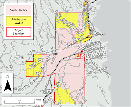
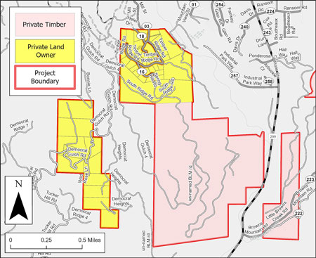
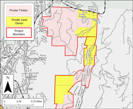
Project Area
Participation map: registered parcels are shown in green. If you believe you registered but your parcel is not shown in green, please call Adriana Rodriguez at (530) 623-6004 ext.224.
Eligible neighborhoods include:
- Weaverville area: Timber Ridge, Upper Little Browns Creek (past the SPI gate), Tye Lane, Democrat Gulch
- Covington Mill: Long Canyon, Strope Creek, Lake Forest Estates, Greenhorn Drive, Millview Drive, Guy Covington Drive, and Grizzly Lane.
- Trinity Center: Swift Creek, Gratten Flat, Rancheria Rd, Norwegian Ranch, Northwoods Estates, and Trinity Lake Knolls.
The following maps show the boundaries of the project area. If you are unsure if you fall within the project boundaries, contact Bethany Llewellyn at This email address is being protected from spambots. You need JavaScript enabled to view it.@tcrcd.net or (530) 623-6004 ext. 220 with your parcel number.
North Lake project Area Overviews

Weaverville project Area Overviews
Information for participating landowners:
- In April - June 2023, an archaeological survey team may access your property. You will receive a phone call or email giving a 1-2 week range when you can expect this survey.
- In April - August 2023, a Northern Spotted Owl survey team may access your property. You will receive a phone call or email giving approximate dates when you can expect this survey.
- Between April 2023 and summer of 2024, TCRCD staff will visit your property and prepare a site plan for treatment. You will receive direct correspondence to schedule this visit. If you do not live in Trinity County, you may review and approve the site plan remotely.
- Implementation is likely to begin in summer/fall of 2024 and continue through spring of 2026. You will be notified prior to implementation on your property.
- If you would like to withdraw from the project, fill out the WITHDRAWAL FORM and turn it in by email to This email address is being protected from spambots. You need JavaScript enabled to view it.@tcrcd.net, by mail to PO box 1450, Weaverville, CA, 96093, or in person to the TCRCD office at 30 Horseshoe Lane in Weaverville. If sent by mail, please call to confirm your form was received.
- If any questions or concerns arise regarding this project, please contact Bethany Llewellyn at This email address is being protected from spambots. You need JavaScript enabled to view it.@tcrcd.netor (530) 623-6004 ext. 220
Why is fuel reduction important?
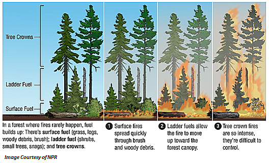
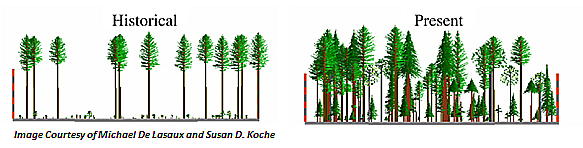
Fire in California wildlands is a natural occurrence, but due to past land management and fire suppression practices, the intensity, rate of spread, and land area burned in high-severity fires have increased over the last century. Scientific studies and historical accounts have revealed that vegetation composition and forest structure has changed dramatically over the last century in northern California, resulting in much less fire-resilient landscapes. 100 years ago, the trees were much more spaced out, and there were older, larger trees in the forests with a primary understory of low vegetation, like perennial bunchgrass. Fire historically passed through Trinity County forests about every 3-12 years. Without restoration of the historical vegetation composition, structures and ecosystems in the wildland-urban interface (the zone where communities and wildlands intersect) are now threatened by catastrophic wildfires due to current hazardous fuel conditions.
Hazardous Fuel Reduction: Focus of this Project
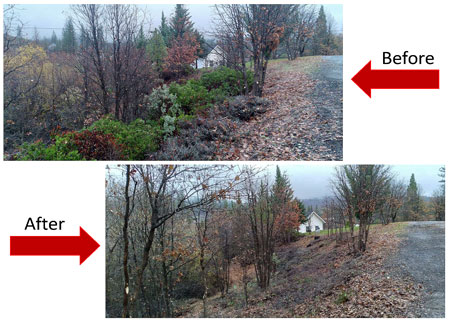
Fuel reduction aims to reduce the continuity of fuels outside the defensible space zone in order to prevent surface fires from becoming high intensity, high severity crown fires. It involves reducing ladder and surface fuels as well as crown density by spacing trees and shrubs vertically and horizontally
Strategically placed fuel treatments not only protect communities but also can protect the surrounding environment from human-caused fires initiating in the wildland-urban interface and spreading to the surrounding ecosystems. Fuel reduction protects homes and the natural spaces that are valued by residents. Ecological benefits include controlling undesirable vegetation such as invasive species, improvement of wildlife habitat and rangeland for grazing, and protection of wetlands and riparian corridors.
