To protect, improve and maintain
the fisheries, natural resources
and local economies of the
South Fork Trinity River Basin
|
SOUTH FORK TRINITY RIVER COORDINATED RESOURCE MANAGEMENT PLAN
- WHAT IS A CRMP?
- Coordinated Resource Management and Planning (CRMP) is a resource planning, problem solving, and management (decision making) process that allows for direct participation of everyone (stakeholders) concerned with resource management in a given planning area.
- PHILOSOPHY
- The philosophy behind the CRMP is that those who live, work, and recreate on a given piece of land are the people who are most interested in and capable of developing plans for its sustainable use.
GOALS
- Develop and implement a coordinated resource management plan for the recovery of the fisheries and economies of the South Fork Trinity River Basin.
- Promote equality, cooperation and voluntary participation among all members of the CRMP process.
- Build trust.
OBJECTIVES
- Provide the leadership necessary to bring diverse interest groups to agreement on resource management opportunities.
- Perform upland watershed analysis and inventory.
- Determine risk potential for sediment yield from private and public land.
- Assess water quality and quantity improvement opportunities.
- Provide access to, and facilitate transfer of, technical information and expertise.
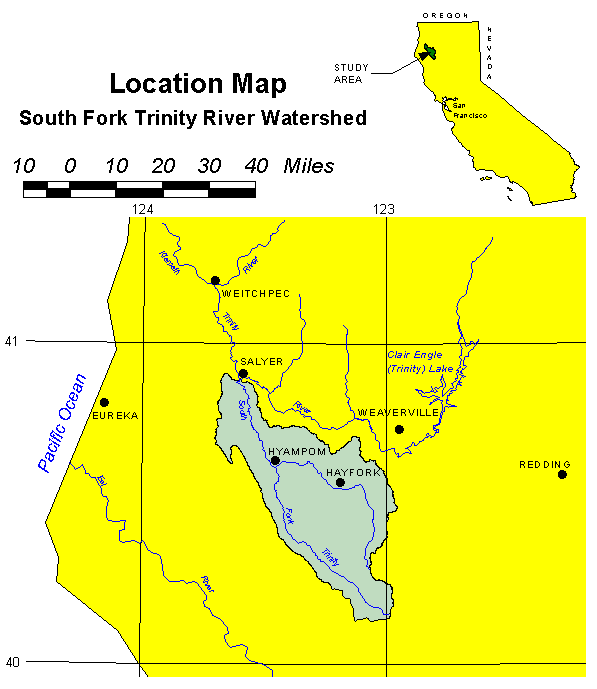
- WHERE AND WHAT IS THE SOUTH FORK TRINITY RIVER WATERSHED?
- The South Fork of the Trinity River is the largest undammed Wild and Scenic River remaining in California. It is one of four sub-basins of the Trinity River watershed. The South Fork watershed encompasses 980 square miles, over 600,000 acres of land. Ownership is 21% private and 79% public. There are 92 miles of mainstem and 585 miles of tributaries in the watershed.
The Hayfork Valley watershed area (the largest tributary to the South Fork) includes approximately 191,000 acres in public ownership and 52,000 acres of private land.
- WHAT RESTORATION IS NEEDED AND WHY?
- The decline of the fisheries in the watershed is generally due to low water flows, high water temperatures and loss of habitat from erosion and other factors. The primary causes of low water flows and high water temperatures in normal rainfall years are irrigation diversions, domestic water use, and loss of riparian vegetation from grazing and clearing, which has reduced stream shade. Sediment from natural flood and fire events, bank erosion, roads and other land uses has filled pools needed for holding areas during fish migration and covered the gravels necessary for spawning.
There are many on-the-ground projects that have been implemented to improve the viability of the South Fork Trinity River Basin ecosystem and others that still need to be addressed.
- RIPARIAN HABITAT IMPROVEMENT
- Riparian restoration includes planting trees to provide more canopy cover to shade the streams and the installation of fencing to protect the riparian corridors from livestock.
- WATER CONSERVATION MEASURES
- Low stream flows, especially in the Hayfork Basin, have been found to damage fisheries and wildlife, restrict available water supply for residential, agricultural and industrial needs and lower water quality for other beneficial uses. Water conservation measures include irrigation water manage-ment to improve water use efficiency, ditch lining, or pipelines in irrigation ditches to reduce seepage losses, and replacement of temporary rock diversions with permanent diversion structures to allow better control of water.
- WATER QUALITY ENHANCEMENT
- Water quality problems affect fish and fish habitat in both the main stem south Fork Trinity River and in its largest tributary, Hayfork Creek. In Hayfork Creek, water diversion, agricultural practices, residential septic systems, and industrial pollution all contribute to water quality problems. These problems can be remedied through the use of pollution control and water conservation measures.
- SEDIMENT AND EROSION CONTROL
- Erosion and sedimentation processes in the South Fork Trinity River watershed have been a significant factor contributing to the historic declines of salmonid stocks in the basin. Restoration work to address this issue includes road closure, road upgrading including treatments at stream crossings and culverts and erosion control work along roads and in stream channels.
- FUELS REDUCTION
- Rural residential development and fire suppression have increased the fire hazard and potential for a catastrophic fire throughout the SFTR. A catastrophic fire could have devastating impacts on the aquatic ecosystem and could threaten any recovery of salmonids in the SFTR. Fuels reduction projects would consist of thinning, brush removal, shaded fuel breaks and stand improvements, etc.
Restoration efforts in the basin will be coordinated by the CRMP through the voluntary cooperation and participation of government agencies, private organizations and individual landowners. This coordination will be supported and facilitated through a series of SFCRMP-sponsored meetings, tours, forums and workshops.
- OUTREACH
- Efforts to reach the public and landowners that will benefit from the process will focus on communication with the general public, land managers, and users of the Basin's resources. The CRMP's objective is to increase awareness of the problems facing the Basin and involve everyone in identification of opportunities for improving the health of the entire watershed. Outreach efforts will highlight education, the sharing of information on research, monitoring and planning activities and provide proactive responses to developing resource issues.
- CRMP PARTICIPANTS
- Participation in the CRMP process is voluntary and includes private industrial timberland owners, Trinity County, AmeriCorps, and small private landowners, and people from various agencies such as the National Resource Conservation Service, US Fish and Wildlife Service, California Department of Fish and Game, US Forest Service, Trinity County Resource Conservation District, California Department of Forestry and Fire Protection, and Water Quality Control Board
FOR MORE INFORMATION
For additional information, or to find out how you can get involved in restoration of the South Fork Trinity River Basin, contact:
South Fork Coordinated Resource Management Planning
Bill Huber, CRMP Coordinator
P.O. Box 1
Hyampom, CA 96046
Phone: (530) 628-5128
E-mail: whuber@jeffnet.org
Return to the Trinity County RCD Home Page
|