RCD Completes South Fork Trinity River Monitoring Project
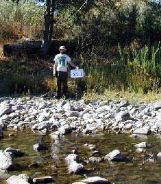 |
Measuring Channel Geometry:
Cross Section & Longitudinal Profiles
Trinity County RCD has just completed a monitoring project of the South Fork Trinity River. The amount of sediment getting into the river has been a concern of fisheries biologists and land mangers. The State of California included the river in its list of polluted waterbodies for sediment. In 1998 the U.S. Environmental Protection Agency set limits for the amount of sediment being discharged in the river in a document called a Total Maximum Daily Load.
The South Fork Coordinated Resource Management Planning Group (SFCRMP) has led the effort to understand the sediment problem and helped the RCD set up a plan with two goals: [1] get a general overview of the watershed – a snapshot, if you will, and [2] try out a method in a couple of tributaries as a way of looking at the effectiveness of restoration projects. The monitoring plan included looking at fine sediments being carried in the streams during storms (sediment loads), surveys of the shape of stream channels (channel geometry) and the sizes and distribution of rocks in streambeds (bulk sampling). The District hired Graham Matthews & Associates, a Weaverville company specializing in river monitoring, to help design and implement the project with the input of the SFCRMP. Monitoring the fine sediment in streams requires measuring the amount of water flowing in the stream during storms and collecting water samples to measure the amount of fine sediment that is in the water during those same storms. To do this a monitoring network was set up that included:
- 34 sites to measure flow and collect water samples
- 18 sites managed by the US Forest Service
- 6 sites for measuring channel shape (geometry)
- 3 bulk-sampling sites on the mainstem of the South Fork Trinity River to look at the sizes distribution of rocks in the riverbed
A team that included staff from Graham Matthews & Associates, the USFS, the RCD, and volunteers from the SFCRMP:
- Collected 253 discharge (flow) measurements.
- Collected hundreds of water samples that were tested for the amount of sediment in the water. This is called suspended sediment concentration.
- Calculated the flow rates at 28 stations. These calculations are called stage discharge relationships or discharge curves.
- Calculated the amount of sediment being delivered to streams based on the size of the streams’ watershed areas.
Using the District’s Geographic Information System (GIS) data for steepness of slopes, geology, fire history, landslides, timber harvest history and road density were used to look at links to the sediment measured in the streams.
Some interesting findings from the report are:
- Different types of geology appear to have little relationship to the amount sediment measured at most of the studied sites.
- The “Hayfork Creek near Hayfork site” (15 on the map) had 211 tons of sediment per square mile and Grouse Creek had 1,200 tons per square mile.
- Barker Creek’s series of monitoring sites helped locate the major sources of sediment, which are in the lower part of the stream. This type of monitoring will be useful in identifying restoration projects and their effectiveness in other watersheds.
- There does not appear to be a simple link between features like road density or percentage of watershed harvested to the amount of sediment being delivered to streams.
- This detailed program of stream flow and sediment transport measurement has quantified substantial differences in sediment yield between sites.
The RCD is grateful to its key partners in this project, including the South Fork Coordinated Resource Management Planning group, a voluntary, landowner-based collaborative; the US Forest Service; California Department of Fish and Game; Trinity County Planning Department and the Watershed Stewards Program of AmeriCorps. Funding for this project was provided by the State Water Resources Control Board’s 205(j) Program, Trinity County Planning Department, and the California Department of Fish and Game.
|