
|
|
|
|
|
In This Issue:
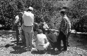
The workshop participants had the opportunity
At least three more workshops are planned, but District Manager's CornerOne way has been through a process called Coordinated Resource Management Planning, or CRMP. A problem, or set of problems, in a watershed is identified and all of the interested parties are invited to share in the development of the solutions. This has been used successfully in the South Fork of the Trinity River to begin to address declining fisheries and economies, the possible reasons for their decline, and the methods that can be used to restore both. It is an ongoing, dynamic process. The management strategies are adjusted, as new information becomes available. Bill Huber, a landowner and grape grower in Hyampom, is the coordinator of the South Fork Trinity River CRMP, and through his efforts the South Fork CRMP group continues to work towards its restoration goals � strengthening existing partnerships and seeking new ones.
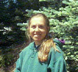
The dedicated efforts of individuals are another important way that we are able to meet the District's goal of landowners assisting landowners. Brenda Reynolds is a good example. Brenda, whom many of you probably have met, came to Trinity County in January. She is a second year, AmeriCorps member with the Watershed Stewardship Program working in the Trinity County Planning Department. Her background, a B.S. in zoology from Humboldt State University and previous work with The Watershed Stewardship Program in Willow Creek, has been a valuable addition to the District's staff. Her field work has included salmon monitoring, and fishery's habitat restoration, but her skills in education and outreach are where she has contributed the most. Last year in Willow Creek she helped to develop classroom and field projects highlighting the importance of our natural resources, especially the rivers and streams. She also coordinated the Trinity River Clean-up during the summer of 1998. This year Brenda has been an important behind-the-scenes player in the District's Stream Care Workshops, and a regular contributor to the Conservation Almanac. Her next major project at the Planning Department will be the Urban Stream Coho Project. This is a part of the Five-County Coho Plan, in which she will assess stream conditions and identify candidate sites for Coho habitat restoration. We at the Trinity County RCD are very thankful that Trinity County Planning Department has been able to share Brenda's skills and time with us, and as a landowner in Trinity County I am pleased to be able to say that the county has benefited from the dedication and efforts of people like Brenda and Bill. Message From the South Fork CRMP CoordinatorBill Huber, HyampomEveryone would like to think they have the answer to improve the rivers in Trinity County. And everyone does! A problem arises when people don't agree whose answer is "right". If you read the Trinity Journal, then it's clear, we've got a problem, because people don't agree, except on some of the most basic facts, like...oh... say... the weather, and even that's open to plenty of discussion (but nobody does anything about it)! So, "How do you "fix" a river?" How are we ever going to come up with an "answer" and get people to agree on something as big and complex as a river? After all, rivers here in Trinity County really start at the top of the ridge and go to the ocean! We're talking BIG problem! Maybe we should look at smaller pieces! Something in the range of 980 square miles, over 600,000 acres. That happens to be the area of the South Fork of the Trinity River, so let's take a look at it as a whole watershed. It's one of the largest unregulated (un-dammed) rivers in the United States!
The South Fork of the Trinity River, including Hayfork Creek, drains the north side of the Yolla Bolly Wilderness and flows north to meet the mainstem of the Trinity River near Salyer. It's mostly uninhabited, with people concentrated in the not-so-huge metropolis of Hayfork, and it's even smaller neighboring communities of Hyampom, Wildwood, and Forest Glen. There was a time when these were booming timber towns. The South Fork and it's environs provided huge volumes of timber that fed mills from Forest Service land and private timber company land, which together cover 85% of the watershed. As with most booms, the resource, (in this case, wood), became less available, and the economy it built and supported collapsed, or "went bust". Trinity County is no stranger to this type of boom and bust cycle. First it was fur, then gold, then wood. As booms and busts go, people and resources get shoved aside. Nobody ever dreamed that we wouldn't have wood available, or that the huge runs of salmon and steelhead could ever be diminished. They were as dependable as the weather! Dependable indeed! The same weather that filled Trinity Lake the winter that the gates were closed on Trinity Dam, flooded the South Fork of the Trinity River, too. To be sure, the South Fork had flooded before, but the intensity of the '64 flood, coupled with all of the roads and cut-over land: gutted creeks and delivered thousands of tons of sediment to the river! Salmon and Steelhead populations diminished as the silt smothered their eggs. BIG, BIG, PROBLEM! Now, we say the South Fork is unregulated. By that we mean no dams. There are plenty of regulations, statutes, ordinances, and opinions that go along with (or against) them! Put the regulations together with a dozen agencies, passionately opinionated individuals, environmental organizations, and private timber companies; "How could we ever hope to agree on anything, much less accomplish anything?" The answer is the South Fork Trinity River Coordinated Resource Management Planning Group! Or South Fork CRMP for short. The South Fork CRMP has had some remarkable accomplishments. We found out that by meeting and talking and planning we CAN agree on some things, and actually work together to accomplish some common goals. From the Coordinated Resource Management Plan for the South Fork of the Trinity River:
This actually happens! Now, I know, meetings are not everyone's cup of tea. But, the South Fork CRMP meetings aren't always the slow, deliberative yawners typical of government, nor are they packed with the rants and raves of angry malcontents. We try to insert a small dose of levity, lest we take ourselves too seriously; and brevity, to avoid the dreaded meeting creep (and to keep from starving!). All with the stated goals and objectives in mind; no small task. Again, from "The Plan": Goals:
Objectives:
So, you might ask, "What has the South Fork CRMP accomplished?" We can agree on the weather. And we have helped all of the agencies get together and identify the problem -- sediment; it's main source � road-related erosion; and the solution -- reduction of sediment delivery to streams by those roads. Through the efforts of the CRMP group, roads get addressed through repairs, upgrades, and/or closed. We have gotten agencies from the county, state, and federal governments and large and small landowners to work together in unique relationships to achieve restoration projects that simply wouldn't occur without a CRMP. The CRMP continues to foster these collaborations and help find ways to fund them, and encourages anyone with an opinion to participate. Little by little, we are working toward the goals where we find agreement. While it won't change the weather, it does make a difference, and it's no small accomplishment! For more information, or to get on the mailing list of the South Fork CRMP, contact Bill Huber at (530) 628-5128, or the TCRCD. South Fork Trinity River Sediment Total Maximum Daily Load (TMDL)The South Fork Trinity River watershed is included on California's Clean Water Act Section 303(d) list as water quality limited due to sediment. The sedimentation in the South Fork Trinity River watershed was judged to exceed the existing Water Quality Standards necessary to protect the beneficial uses of the basin, particularly the cold water fishery. Accelerated erosion from past and present land use practices and natural sources impacts the migration, spawning, reproduction, and early development of cold water fish such as spring and fall run chinook salmon and steelhead trout. The South Fork Trinity River TMDL was completed by the US Environmental Protection Agency (EPA) in December 1998. The EPA was committed to develop TMDLs for 18 rivers by December 31, 2007 as a result of a consent decree entered in the US District Court, Northern District of California (Pacific Coast Federation of Fisherman's Associations vs. Marcus). The purpose of the South Fork TMDL is to identify sediment loading targets that, when implemented, are expected to result in the attainment of applicable water quality standards for sediment. The components of the TMDL include:
The TMDL was developed by reviewing and analyzing existing data on instream resources and desired conditions. The numeric targets were developed based on literature sources, existing data for the South Fork, and best professional judgment. A sediment source analysis was developed to determine sources and quantities of sediment delivery to the stream system utilizing air photo analysis, modeling and literature-based erosion rates to estimate sediment production over time. This analysis estimates that sediment delivery to the stream averaged 1,053 tons per square mile per year over the period 1944-90. This report concludes that an overall improvement of about 30% from the historical sediment loading rate would achieve target conditions, although there is variation between indicators. Targets include fish population recovery, channel form and structure recovery, improved substrate size distribution, as well as decreased sediment delivery. Implementation and meeting the targets of this TMDL is the responsibility of the North Coast Regional Water Quality Control Board. This TMDL addresses only sediment impairment. High temperatures were identified as additional sources of impairment in the 1998 303(d) listing process, but were not included in this TMDL. The EPA indicates that temperature impairments will be addressed in a future TMDL. CFIP FUNDS AVAILABLE FOR LANDOWNERS
CFIP is a state-funded program aimed at improving the economic value and environmental quality of forestlands. CFIP can help rebuild forest and wildlife resources to meet our future needs for a healthy environment and productive forests. Forest landowners can be reimbursed up to 75% of their expenses for the following practices: Fish and wildlife habitat improvement, including creation of corridors and openings, planting blue, valley, coast live or Engelmann oaks or riparian species, installing exclusion fencing along watercourses and wetlands, and stream restoration projects.
The minimum project size for tree planting or thin/release work is five acres and 20 acres for forest resource management projects. Erosion control and fish and wildlife habitat improvement projects have no size limitations. Any work required under the Forest Practices Act is not eligible for CFIP funding. Ninety percent cost share rates are provided for work on lands damaged by wildfires, insects, disease, wind, floods, landslides or earthquakes during the last ten years. Please contact Duane Shintaku at the California Department of Forestry and Fire Protection (530) 623-5681, if you have any questions or would like to submit an application.
KIDS PAGE
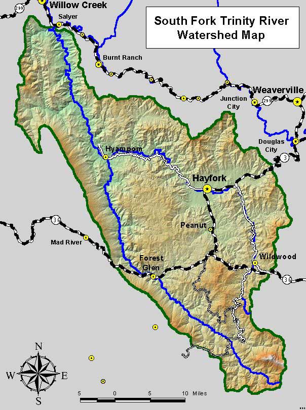
South Fork Trinity River WatershedThe South Fork Trinity River watershed is a large area of Trinity County, covering about 980 square miles. Thousands of insects, birds, mammals and fish, including humans, make their home in or near the many creeks and streams in the South Fork watershed. Look at the map of the South Fork Trinity River watershed on the right of this page. Do you live in this watershed? Have you visited any of the places identified on the map? Try to name 20 types of living creatures found near your home. Write them down on a piece of paper. Next, unscramble the following words of animals found in the watershed. How many words match your list of creatures?
Return to the Trinity County RCD Home Page
|
||||||||||||||||||

 Funds for fish and wildlife habitat improvement, tree planting, thin and release, and erosion control projects will soon be available through the California Forest Improvement Program (CFIP).