|
| Fall 1997
| Vol. VI, No. 4
|
In This Issue:
|
Conservation Assistance for Landowners
Resource
Conservation
Directory |
Originally intended to be part of this
newsletter, the Conservation Guide
for Landowners quickly expanded to
many pages as it was being developed.
The Directory contains information on
where to find help on the following
topics:
- Agriculture
- Forest Health
- Fuels Reduction
- Livestock-Exclusion Fencing
- Native Plants and Seed
- Permits
- Pond Construction
- Road Drainage Improvement
- Sediment Reduction
- Spring Development
- Soils
- Water Quality/Aquatic Health
- Weed Control
- Wildlife Habitat Enhancement
|
Many Trinity County landowners may not know about the diverse resource and assistance programs available to them for help with conservation and enhancement of resources on their lands.
Because of our mission to "assist people in protecting, managing, conserving and restoring the natural resources of Trinity County" the Trinity County Resource Conservation District (RCD) has created a Resource Conservation Directory for Landowners. The Directory lists agencies, businesses, and individuals who offer assistance to landowners and residents of Trinity County who need help with managing natural resources or developing the economic potential of their properties.
The Directory is free to anyone who wishes to receive a copy. Please contact the RCD to receive one.
Return to this issues index.
|
Trail Tracks
News From the Weaverville Basin Trail
The development of the Weaverville Basin Trail is a success story in a cooperative, primarily volunteer effort. The Weaverville Basin Trail Committee is a group of dedicated trail enthusiasts who have worked together with small private landowners, the Forest Service, the Bureau of Land Management, Sierra Pacific Industries, the Planning Department and various interest groups such as horse riders, mountain bikers, hikers, and off-road vehicle users in order to obtain easements or right-of-ways and to address various concerns so that the trail system could be developed with the best outcome for all.
Those involved in the project have been able to achieve a tremendous amount although there is much more that remains to be accomplished. We are now at a point in this process where we are looking for sponsors to help pay for the necessary signage and maintenance required. An Adopt-A-Trail program is being considered, whereby a company, family or individual adopting a certain section of trail for a specified fee would be responsible for any maintenance or clean-up required. Sponsors would be identified on the trail sign. The following people and organizations have contributed significantly to the progress of the Weaverville Basin Trail system to date:
- Scott A. Morris, the Chairman of the Weaverville Basin Trail Committee, has devoted countless hours to the development of the trail system. His passion for the trails and his belief in its importance to the community has generated enthusiasm for tackling this somewhat complex project.
- U.S. Forest Service prepared the Environmental Assessment for the trail system. The majority of the trail system is on Forest Service Lands and their full cooperation has been instrumental in enabling this project to become a reality.
- Trinity County Planning Department included the trail system in the Weaverville Community Plan and ensures that as development in and around Weaverville occurs the trail system will be considered.
- Trinity Conservation Camp donated labor for brushing new sections of trail, installing posts for a motorized vehicle barrier, and milling cedar wood to be used for signs at trail access points.
- AmeriCorps Watershed Project constructed a footbridge and implemented trail repair projects.
- Trinity County Resource Conservation & Development (TCRC&D) and the Resource Conservation District (RCD) have adopted the Weaverville Basin Trail as a project by their respective Boards of Directors and developed a proposal for funding a Master Plan as well as assisting in facilitating volunteer trail days and committee meetings.
- CalTrans donated posts for signs as well as railroad ties and asphalt grindings.
- Ron Adams volunteered a significant amount of personal time to prepare a map of the trail system. Sales of this map at the La Grange Classic Mountain Bike Race have allowed for the purchase of some carsonite signs for the trail.
- Trinity Occupational Training (TOT) provided crew for inventory and storm repairs of the trail system in Weaverville (and Hayfork).
- Jim Love has developed and installed signage for the trail utilizing posts and a numbering and mileage system so people will be less likely to get lost and now know how far they are going. He has also performed a significant amount of trail improvement work.
- Trinity Alps Bicycle Association (TABA) reopened the Howe Ditch route and performed a significant amount of trail maintenance work.
- Trinity Riders and Trinity Road Runners have also been involved in trail maintenance work.
- Erik Flickwir of Trinity Mountain Design is working with the trail committee to design and produce signs for the trailheads.
The Weaverville Basin Trail now has an account set up at both recycling centers in town so individuals can donate funds from their recycling to the trail system to assist in sign purchases and trail maintenance.
One of the more recent developments on the Weaverville Basin Trail system is to survey and flag the proposed right-of-way along West Weaver Creek, from Oregon Street, down to the Industrial Park using the Global Positions Satellite system. This is land that is slated for trade-out from the Bureau of Land Management to Sierra Pacific Industries. The Weaverville Basin Trail Committee is working with both the BLM and SPI to come up with a mutually agreed upon route through this very interesting riparian zone and the historic mining tailings which provide important archeological and historical interpretive opportunities.
A similar effort to develop a system of trails has begun in the Hayfork area as well. The system has been outlined in the Hayfork Community Plan and a brochure has been developed by the Forest Service for the Indian Valley and Butter Creek area depicting and describing in detail the road and trail system currently in place. Stop by the Forest Service in Hayfork for a copy of this brochure or contact Bob Mountjoy of the Hayfork Action Team, Recreation and Tourism Committee, for more information on how to get involved (916) 628-4474.
Monthly meetings of the Weaverville Basin Trail Committee, which currently has over 20 members, are held the first Wednesday of each month. More volunteers with time, materials, ideas, expertise, and/or funds are needed. If you are interested in participating and/or being a sponsor in the development of our community's trail system please phone Noreen Doyas at the RCD.
Return to this issues index.
Current Projects
RCD Implements Restoration and Conservation Work
Work is underway or recently completed in many parts of the county on a diverse array of projects:
Erosion-Control Projects
- Trinity High School
- Over the summer Trinity High School expanded its entrance road and parking lot to accommodate increasing numbers of students parking and increased traffic flow. Expansion of the parking lot, however, created a potential erosion problem on a newly created fillslope. The RCD assisted with erosion control by donating 750 yards of “Enkomat,” a type of loose-weave netting intended to provide stability to steep banks, while allowing plants to grow through the netting. The RCD also donated surplus seed and fertilizer to vegetate the slope.
- The Ranch On Rush Creek
- Work on the Hardt ranch on Rush Creek was completed on September 11. The storms of January 1997 caused Snow Gulch, a small creek on the Ranch, to divert away from its natural channel, causing extensive erosion and subsequent delivery of decomposed granite (DG) sediment into Rush Creek then downstream into the Trinity River. The project involved building a berm to divert water from Snow Gulch back into its natural channel. Incorporated into the berm were a basin and pipe, which allow the landowner to safely divert flow from the creek into an irrigation ditch, which flows into a pond for wildlife habitat and fire-suppression.
Road Improvement Projects
- East Fork
- An agreement between the US Forest Service (USFS) and the RCD was signed that allows the RCD to implement work in the East Fork of the South Fork Trinity River. Projects will include installing rolling dips and sediment risers and upgrading culverts to help protect the watershed during large storms. The work was made possible by the the research conducted by the RCD and others as part of the East Fork/Smoky Creek watershed analysis.
- Grass Valley Creek (GVC)
- The RCD is implementing various road-related projects in the GVC watershed. One of the projects involves the surfacing of nearly one mile of road with road grindings donated by Milt Apple of CalTrans. This road has historically required high maintenance (it is located in DG soils) and is vital for access into the upper portions of the GVC, Indian Creek, and Corral Creek watersheds. Resurfacing the road will allow faster and safer response by crews in the case of fire and other RCD activities in the watersheds.
- Lemonade Springs
- Another landowner requested road improvements off of the Lemondade Springs Road. This road, which leads to the South Fork of the Trinity River was erosion proffed by the installation of rolling dips.
- Pelletreu Creek
- Work on Simpson Timber land in Pelletreau Creek upgrading culverts to 100-year storm standards has been completed. Thank you to Simpson for allowing the RCD to implement road-improvement measures on their lands!
- Post Mountain
- Road maintenance continues within the Post Mountain area. Post Mountain is in southern Trinity County, about 15 miles southwest of Hayfork. To date, the RCD has installed many rolling dips and ditch-relief culverts , all aimed at reducing sediment delivery to Post Creek, a tributary to Rattlesnake Creek and then the South Fork of the Trinity River. This large subdivision has very high road densities due to access provided for the small one- to three-acre lots. As documented in a 1990-91 Rattlesnake Creek report by the USFS, these roads are susceptible to excessive sediment production. Future work will consist of the rock resurfacing of some sections of roads.Because the residents of Post Mountain appreciate the improvements to their road network, and the long-term goal of sediment reduction will also be met, this is a win-win situation.
Riparian Enhancement
- Big Creek
- The RCD revegetation staff assisted the Natural Resources Conservation Service (NRCS) in developing a monitoring program for the Big Creek riparian fencing project. Fenced areas were also inventoried to determine planting sites, tree species, and quantities needed.
Streambank Stabilization
- Tule Creek
- The Tule Creek project on the L&M Ranch will involve moving nearly 800 cubic yards of stream gravel out of the main channel where it has aggraded, causing the flow of the creek into a highly eroding stream bank. Large logs will be utilized to protect this bank from further erosion.
- Salt Creek
- Two projects will be implemented on Salt Creek. The Kennerson project involves pushing an aggraded plug of sediment out of the main channel onto the floodplain. Nearly 100 feet of a highly eroded streambank will be protected from further erosion by placing approximately 200 tons of three- to five-foot riprap (large, angular rock) along the bank. Both of these streambank stabilization projects will protect cattle-exclusion fencing and riparian plantings as well as reduce sediment to streams.
- Jungwirth Property
- This project involves placing riprap along approximately 130 feet of eroding streambank. Landowner Dick Jungwirth will supply all materials, equipment and labor.
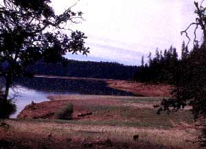
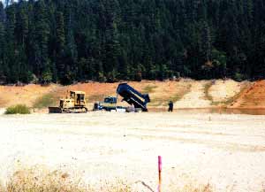
Beach Improvement
- Clark Springs
- Truck loads of sand-like decomposed granite soils were delivered to Clark Springs Beach on Trinity Lake to restore the recreation area. (See photos this page).The sand was dredged from ponds near the mouth of Grass Valley Creek (near Lewiston) designed to prevent the migration of sediment into the Trinity River.
The Clark Springs beach site before
decomposed granite was placed on the site.
 |
Decomposed granite is spread on the
site at Clark Springs to restore the beach.
 |
Revegetation
- Fall Planting
- Currently, additional stock is being ordered to meet the needs for this fall’s planting season, with plants for both the Indian Creek and Hayfork Riparian projects. All of the areas in GVC for planting (as listed in the 10-year revegetation plan) have been inventoried and planting prescriptions written.
- Monitoring
- Monitoring has been completed on sample sites to determine the one-year survivability rate on plantings done during the spring and fall of 1996. Along with survival counts, sample seedlings at each site were measured for height to determine the amount of growth during the year. Sample sites were also monitored for the germination and growth of acorns planted last year.
- Site Identification
- Permanent marking of restoration sites has been completed for the GVC watershed. The revegetation staff is now working with the RCD’s GIS/Data Manager, Kelly Sheen, on updating and correcting database maps so that there are accurate and complete maps of all the restoration work completed in the watershed.
Publications/Research
- East Fork/Smoky Creek WA
- The final touches are being put on the East Fork/Smoky Creek watershed analysis (WA) that was jointly undertaken by the RCD, the USFS, the NRCS, and others. The WA team’s editor, Scott Brennan-Smith, is planning to finish the draft report and deliver copies to the USFS and other interested individuals and agencies this fall.
- Star Thistle Research
- With the assistance of the Resource Conservation and Development Council’s Scott Eberly, RCD Revegetation Manager Christina Veverka is writing a proposal to the Environmental Protection Agency’s Department of Pesticide Regulation to conduct research on star thistle eradication.
- GVC Restoration Manual
- The GVC Restoration manual has been on hold while the editor completes the East Fork/Smoky Creek WA. Drafts were sent to peer reviewers in early summer, so once those are received back the final edit can be completed, hopefully by late fall.
- Native Grass Nursery
- RCD revegetation coordinator Dana Sandifer published an article on the RCD’s native grass nursery project in this fall’s issue of the Journal of the Native Plant Society. Because of their extensive use of natives in the GVC watershed, the RCD found it most cost-effective to use native grass collected from the watershed itself in its revegetation efforts. Also, these plants are perfectly suited to the climate, as they have adapted to the very sites for which they are intended. •
Return to this issues index.
River Facts
The Trinity and the Flows
This fall, the Trinity County Board of Supervisors has been offering forums on the upcoming decision by Interior Secretary Bruce Babbit on revised flow regimes for the Trinity River.
This issue is controversial and hotly debated. On September 16, Tom Stokely, Senior Planner for the County, presented an information workshop intended to provide the public with the facts they would need to give input to the Board on their wishes for the flow decision. Tom Stokely made it clear that the flow decision was not in the hands of Trinity County alone, but that the County could present a recommendation to the Interior Secretary as part of an advisory team that includes the County, the Hoopa Tribe, the Bureau of Land Management, and the US Fish and Wildlife Service.
As part of this informational workshop fluvial geomorphologist Scott McBain delivered a presentation on what constitutes a naturally functioning, healthy river, one that is unimpeded by human disturbance. He acknowledged that before the construction of Trinity Dam, the Trinity River functioned as a natural system, but that since then normal river functioning has been drastically curtailed by the reduction of flows due to the dam and diversion of the majority of Trinity River water to the Sacramento Valley.
Noting that a healthy river means healthy habitat for fish and other wildlife, McBain stated that a naturally functioning river system is dependent on several factors, which he discussed briefly at the meeting:
- A healthy river has "spatially complex channel morphology." This means that natural river systems have variations in stream channel structure, including pools, riffles, point bars, and sheer zones (fish feeding zones).
- Variability is key also when it comes to flows and water quality. Healthy river systems have highly variable and unpredictable flows over time, from slow trickles to raging torrents.
- A healthy river also has a balance of fine and course sediment. Different species have different habitat needs. Anadromous fish (salmon and steelhead) especially need coarse gravels for spawning. Coarse gravels from higher up in the watershed are now trapped behind the dam, creating a preponderance of fine sediment downstream.
- A healthy river has a "frequently mobilized stream bed" that is "cleansed", on average, once a year. Occasional, very high river flows scour out sediment in some places and deposit sediment in others. This, again, creates a complex and changing environment for fish and wildlife. Occasional high flows also kill off vegetation in the riparian zone, depositing large and small trees in the river (which is good for fish habitat), further creating a diverse and ever-changing environment.
- Naturally functioning rivers also experience "periodic channel migration", which means the river meanders within the flood plain and does not always flow through the same channel.
- A healthy system also has a "functional floodplain", with frequent flooding within the channel and occasional, "25-year" "channel-resetting floods" of up to 100,000 cubic feet per second flows. Such very high flows were eliminated in the Trinity River when the dam was built. These high flows not only wash out built-up sediment, they kill off riparian vegetation in some areas, again creating a diversity of riparian zones, some with young trees, some with old trees, and others with no trees at all. Diversity of wildlife communities requires a variety of riparian habitats.
- A healthy river also requires a naturally functioning groundwater table.
McBain stated in conclusion that the Trinity River is far from being a naturally functioning river system. Scouring of the channel no longer occurs, so sediment buildup is never alleviated. Riparian zones continue to age without the "resetting" mechanism of high flows, thus failing to establish variability within the riparian community that is beneficial to a wide range of wildlife.
Also, fry and juvenile anadromous rearing habitat has been eliminated because of the uniformly fine particle size of sediment. Historically, fish rearing took place in the upper reaches of the river where coarse gravels predominated. Now, fish are forced to use the lower portions of the river, which once had been used migrationally only, as spawning and rearing habitat for which it is poorly suited.
With the dam in place, the river will never be able to function as a completely natural system, but the question remains: Can an alternative flow regime restore at least some of the features that create a healthy river system? There are several alternatives proposed to address the issues discussed above. As these issues are addressed in future Board of Supervisors’ meetings they will be reported in the Conservation Almanac as space permits.
Return to this issues index.
Employee Feature
Key Player: Kelly Sheen
 Kelly Sheen is Geographic Information System (GIS) manager at the RCD. Kelly is the man at the RCD in charge of acquiring and creating "tabular and spatial data sets" for the various projects the RCD implements. Such data is crucial for creating maps to determine locations of revegetation and equipment work, documenting work completed, and monitoring project success over time. It is also important for determining geologic and other conditions of specific sites such as slope, aspect, plant communities, wildlife habitats, man-made features (such as roads), and more. Kelly Sheen is Geographic Information System (GIS) manager at the RCD. Kelly is the man at the RCD in charge of acquiring and creating "tabular and spatial data sets" for the various projects the RCD implements. Such data is crucial for creating maps to determine locations of revegetation and equipment work, documenting work completed, and monitoring project success over time. It is also important for determining geologic and other conditions of specific sites such as slope, aspect, plant communities, wildlife habitats, man-made features (such as roads), and more.
GIS mapping is an approach to creating and storing geographic information in the form of maps that are linked to data sets. A user of the system can find out detailed information about specific locations on a map. For example, you can click on a road and link to the data set associated with that road, finding out the type of road, where it is located (by coordinates), how wide it is, how long it is, and who owns it.
Kelly was born in Eureka, but has lived for the most part in Trinity County since he was 1-1/2 years old. He attended Trinity County schools, graduating from Trinity High School in 1988. His few years away from Trinity County took him to the Phoenix Institute of Technology, where he studied Architectural drafting and Computer-aided design and drafting. He also lived in the Bay area for several years, working for an Architectural firm. He returned to Trinity County, which he has always considered his home, in 1993, and worked for Registered Professional Forester Terry E. Sheen (his father) for several years before starting work at the RCD in August of 1995.
Kelly met his wife Fran Aldrich, a clothing designer by avocation and a shipper for Aura Cacia by vocation, while they attended Trinity High. Kelly loves Trinity County because of the recreation opportunities (he likes to hike and mountain bike) and because his family is here. Besides his father, Terry, and mother Diane, a professional photographer, he has two brothers, Cody and Allan, an uncle, Ron, and a grandmother, Ione, all of whom live in the area.
 When he’s not at work clicking the keys on his computer, Kelly spends more time at home clicking keys--on his musical instruments. Kelly has played keyboards for six years and says that music has always been a vital force in his life. He likes jazz, rock, and folk music, but he’s especially interested in the live, performance aspects of music. When he lived in San Francisco he met and became close friends with a group of musicians known as Skyclad, and Kelly found being immersed in the community centered around the band to bring him human interactions he had never experienced before...nor has he since. Knowing the musicians of a band he admired revealed to him the human side of music, why musicians play, and what the feelings and ideas behind the music are. This community had an openness and ability to experience the joy of being alive. When he’s not at work clicking the keys on his computer, Kelly spends more time at home clicking keys--on his musical instruments. Kelly has played keyboards for six years and says that music has always been a vital force in his life. He likes jazz, rock, and folk music, but he’s especially interested in the live, performance aspects of music. When he lived in San Francisco he met and became close friends with a group of musicians known as Skyclad, and Kelly found being immersed in the community centered around the band to bring him human interactions he had never experienced before...nor has he since. Knowing the musicians of a band he admired revealed to him the human side of music, why musicians play, and what the feelings and ideas behind the music are. This community had an openness and ability to experience the joy of being alive.
Since then Kelly has tried to recapture and express that experience through music. Yet he is humble about his accomplishments. "I haven’t really begun yet to create with music. I’m still learning the art form." Despite this humility, he doesn’t pass up opportunities to perform with his band, The Vine, which includes, besides himself, his wife Fran, his brother Allan, and occasionally Steve Roadhouse and Scott Brennan-Smith.
For the future Kelly plans to remain in Trinity County, continue to play music and his work with resource conservation. He hopes that through his skills on computer he can contribute toward balancing the seemingly opposing interests of resource utilization and resource conservation, two "necessities in an area that is often times so divided, in the hope that a balanced life can be sustained for the community."
Return to this issues index.
Decomposed Granite Give-Away Day
The RCD has received numerous phone calls from people in response to the article in the Summer 1997 issue of the Conservation Almanac on utilizing excess decomposed granite (DG).
Many people in the county are interested in using DG in their gardens (it is beneficial in soils that have too much clay). DG is dredged from various sediment basins in the Grass Valley Creek watershed that keep it out of the Trinity River.
The RCD is currently organizing an opportunity to allow landowners of Trinity County take this sand-like material free of charge, as long as they are willing to bring a truck to haul it.
Hauling DG in large quantities is costly, but people willing to transport it themselves from a location near Buckhorn Summit would be able to acquire amounts of DG suitable to use on their properties at only the expense to haul it home. A date has not been set for the give-away, but we expect it will be during the spring of next year. We’ll keep you posted. If you are interested in signing up for the give-away day, please give us a call and we’ll add you to our list.
Return to this issues index.
Spring Tour Date Set
This coming March, the RCD and the Natural Resources Conservation Service will host a Spring Tour of conservation projects implemented in the Hayfork Valley. These projects include riparian restoration, cattle management projects, streambank stabilization, fuels reduction, brush clearing, and a demonstration on the use and successes of the RCD’s no-till drill. This tour will be open to the public and will include a bar-b-que. We look forward to seeing you there!
Return to this issues index.
Return to the Trinity County RCD Home Page
|

