|
|
|
|
|
In This Issue:
Fuels Reduction in Hayfork ValleyIt could be started by anything--a lightning strike on a hillside, a cigarette casually thrown from a vehicle, the spark from a backfiring tractor--but once it gets started it may rage frantically and uncontrollably through brush, forest and property alike. Several land owners in Hayfork realized their danger and decided to take the Trinity County Resource Conservation District (RCD) up on their offer to participate in a demonstration project to reduce the risk of fire by clearing underbrush and thinning trees--a process known as "fuels reduction"--along roads and near buildings on their properties. The TCRCD garnered funds available through a cost-sharing arrangement with the Agricultural Conservation Program (a part of the Farm Services Agency) and worked cooperatively with Community Geographic Information Service, US Forest Service, California Department of Forestry and Fire Protection (CDF), and the Watershed Center in Hayfork to begin work on eight adjacent properties along Hyampom road in Hayfork. The "natural" look of dense undergrowth and dark, tangled masses of bushes and trees is really quite un-natural. It is only recently that aggressive fire-suppression campaigns gave fire a bad name and made it the forest�s deadliest foe. In actuality, naturally occurring fires can be a friend to forest habitat, and Native Americans have long viewed fire as a forest-friendly tool for reducing the risk of catastrophic fires, for regenerating certain conifers, and restoring nutrients to the soil. Ironically, the risk of disastrous fires has increased in the wake of fire-suppression efforts of the last thirty years or so. This year�s major fires in both Northern and Southern California bear witness to this fact. Fuels reduction is seen as a safe alternative to controlled burning, which, as in the raging 1996 Montana fires, can get out of hand and lead to uncontrolled, catastrophic burning over large areas. Fuels reduction addresses the problem of fire "ladders" (dense underbrush and lower tree limbs) without the risk of sparking wildfire.
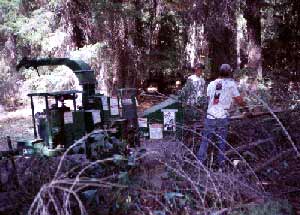
RCD chipping brush and limbs in Hyampom. It is labor-intensive, however. A crew of five TCRCD employees worked for nearly a month in the dense undergrowth along Hyampom road, sawing limbs, clearing manzanita, thinning trees and running cut material through a "chipper" to turn the cut branches into mulch. But landowners and others seriously interested in reducing the risk of fire in the area agree it was well worth the effort. Once work got underway on one property interest spread like wildfire among neighbors of Chuck George, who signed on early in the project. Residents agree that not only are they safer from the risk of fire, but the clearing of underbrush and debris gives their properties a new, park-like atmosphere: views of tangled undergrowth have turned to clear views up hillsides and through trees where one can catch a glimpse of Don and MaryAnn Coon�s beautiful white alpine-style home festooned with balustrades, birdfeeders, and curving walkways. The TCRCD will continue spreading the news about fuels reduction and in February expects to begin work on other Hayfork property with a CDF Stewardship grant.This grant is a cost-sharing program and landowners will be expected to contribute at least 25 % of the total cost of doing the work. Fire
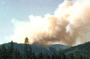
1995 Browns Mountain Fire. Total fire suppression does not prevent wildfires; in fact, it makes matters worse. Fires are a natural feature of mountain environments and frequent burning prevents the long-term destruction by wildfires at some later time. In the primitive forests of California, crown-fires were rare whereas frequent ground fires of low intensity, ignited by Native Americans were a common feature. California�s primitive forests were kept open and park-like by frequent surface fires set by lightening and by Native Americans. The forests were in a stable equilibrium, immune to extensive crown fires. The problem of wildfires is related to the large and unnatural accumulations of fuel with the result that crown-fires of catastrophic proportions develop, and the succession pattern which follows is markedly different from that which follows light burns. Wildfires have often caused the development of brushfields with almost totally degraded forests, the process of recovery to a mixed coniferous forest being greatly impaired. In forestry, the main purpose of prescribed burning is to enhance the production of growth of certain trees, by manipulating the major environmental factors that influence reproduction and growth: light, temperature, water and mineral nutrients. Fire reduces brush cover to favor a parkland of grasses, trees and intermittent stands of brush. The general effect of fire is to check succession, reduce competition, remove aged and diseased trees, increase plant and animal activity, and improve the flow of springs by maintaining a sub-climax condition. Frequent fire is the agent of soil regeneration, releasing the nutrients from plant tissue and recycling them into new biomass. Fire has even influenced the evolution of various species of the forests, grasslands, and xeric (dry) shrub communities in mediterranean climate regions of the world such as those characteristic of California. Home Fire ProtectionIt is important to create a defensible space around houses on forested homesites. Fire hazard can be reduced if you follow the these safety guidelines:
Weaverville Basin Trail SystemThis fall, the Weaverville Basin Trail Committee Chairman, Scott Morris, requested the Trinity County Resource Conservation District (RCD) to be the lead agency to help the Trail Committee fulfill its goal of creating a basin-wide trail system. The RCD has agreed to adopt this community-development project and to facilitate funding and trail maintenance. The Trail Committee now functions as a sub-committee of the RCD Board of Directors. Members of the volunteer Committee have been working for more than ten years to designate approximately 40 miles of trail, complete an Environmental Assessment with the Forest Service, and include the preliminary trail system map in the Trinity County General Plan. The Weaverville Community Plan is being amended to accurately reflect the trail system and to protect it as development progresses in the basin. The Trail Committee submitted a Community Economic Revitalization Team (CERT) proposal for funds to develop a Master Plan for the System and for trail maintenance and development. The proposal was prepared by the Resource Conservation & Development Coordinator, Scott Eberly, with assistance from members of the Trail Committee. The Weaverville Basin Trail system is unique because of the many opportunities that exist for interpretation of historical sites and natural features, and it incorporates the overall historic theme of the community. The RCD supports the effort to complete a "Trail Through Time" to be enjoyed by the local community and tourists interested in hiking, biking, horseback riding, and sightseeing. The trail system will provide users with a sense of wilderness adventure but also offer hot showers, good meals, and comfortable accommodations at the end of the day. This in turn will provide much needed revenue to the community as well as local businesses, which have been hard hit by changes in the timber-based economy. A Memorandum of Understanding (MOU) between the RCD and the Forest Service--the primary landowner of the trail system--was recently signed by the Shasta-Trinity Forest Supervisor, Sharon Heywood, and the RCD Chairman of the Board of Directors, Gregory Lowden. The purpose of the MOU is to provide a framework for cooperation between parties in support of the trail system. Construction and maintenance of the trail will enhance the recreation experience of area hikers, mountain bikers, equestrians, and, to a limited extent, Off-Road Vehicles (ORV�s). One of the efforts currently being made by the Trail Committee is to educate local ORV users about the sections of trail that are off-limit to motorized vehicles. In a letter to the editor of the Trinity Journal, the Committee pointed out that in order to obtain access on private lands within the system, permission was granted in many cases only if motorized use was not to occur. Many locations still exist in the basin for ORV use, but in order to maintain trail access for a majority of users, it is critical that the trail designations be followed. The volunteer Committee invites ORV users to participate in development of the trail system so that all uses can be effectively planned. Caltrans has donated a pickup-truck load of treated wood posts for use as trail signs for the project. Boy Scout Troop No. 15 is assisting in making the signs as part of their effort to earn Eagle Scout Merit badges. This project is now a cooperative effort, with many interested people helping to move this project forward. Other ideas about getting community members even more involved include: having a logo contest for the Trail System by local artists, developing an Adopt-A-Trail system, and organizing a "Volksmarch"--a thematic fundraising walk-- as a means of generating funds for the trail system. The Trail Committee meets every second Wednesday of the month at 7pm at #3 Horseshoe Lane in Weaverville. Everyone interested in the Weaverville Trail System is welcome and encouraged to attend. Restoration Work Begins on Indian CreekWork began in September on a stream restoration project on Indian Creek. The stream reach between Mule Gulch and Frietas Gulch has never recovered from hydraulic mining disturbance, which occurred in the early days of Trinity County settlement. The disturbed channel was unstable, poorly vegetated and had intermittent flows in the late summer season. Before the mining disturbance, Indian Creek was an important part of Trinity County�s productive anadromous fishery supporting abundant salmon and steelhead populations. Stream channel conditions restricted migration, spawning and rearing of this valuable fish resource. Those cooperating in the project include the Bureau of Land Management, the lead agency, the Natural Resources Conservation Service, the Trinity County Resource Conservation District (RCD), and private land owners. Project participants hope to improve the long-term health of the stream for the fish and stop extensive bank erosion caused by frequent stream-course changes. The project seeks to create a stable stream channel that will improve flow and habitat conditions throughout the year.
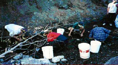
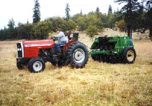
RCD crew rescues steelhead and salmon before restoration work begins. Survey crews at the site were surprised to discover hundreds of young fish (mostly steelhead) surviving in the creek, indicating the stream is still an active spawning and rearing site for anadromous fish. These fish are at risk due to diminished surface flow, elevated water temperatures, and a lack of cover. Fish in the immediate project area were captured and relocated within Indian Creek. Initial work on the creek utilized heavy equipment to construct a channel along a course interpreted from historic photos. Ron�s Backhoe Excavating of Hayfork and Manning Construction of Redding were awarded the construction contracts. Such projects coordinated by the RCD frequently utilize local businesses such as Ron�s Backhoe, contributing to the health of the local economy as well. By early October, the work crews had finished the new stream channel architecture, and some of the water from the creek that had been diverted was allowed into the new channel to begin replenishing the ground with water. Once the new stream course is firmly established, crews will plant willows, alders, cottonwoods, and other riparian species to revegetate the area and create a functional riparian zone. Healthy vegetation on stream banks provides shade to keep the water cool for the fish, establishes root structure to prevent erosion, and traps sediment. It is hoped that such efforts will create improved habitat for the fish, as well as decrease erosion and deposition of sediment in the main stem of the Trinity River downstream from the site. Future monitoring of the physical habitat of the creek and its anadromous fish populations will determine if the project is achieving the desired effect. Trinity Agriculture ForumThe Trinity County "Ag" forum is a coalition of farmers, ranchers, and other property owners interested in developing new agricultural strategies for Trinity County farm- and ranchland. The main interest of the group is building relationships among group members, which also include employees of local government agencies such as the Natural Resources Conservation Service, The Resource Conservation and Development Council, and the Resource Conservation District. The monthly meetings serve as a forum for building trust between members, sharing information on new agricultural products and strategies, and finding out what others are doing. The group plans to sponsor a workshop on viticulture (grape growing), one of the new agricultural items sparking interest in Trinity County, early in 1997. For information on Ag Forum meetings and other events, contact Scott Eberly at 623-2009. No-Till Drill Demonstration Day
Dave Copeland pulls the No-Till Drill at the demonstration. The drill is stored at the Trinity County Fairgrounds and will be administered by the fairground manager, Jerry Fulton. Mr. Fulton anticipates there to be a fair amount of use of the drill and said that "three people have called me already about renting the drill and I expect there to be more." There is a $75.00-a-day rental fee for the drill. In addition, it is recommended that the drill be pulled with a 45-hp tractor with external hydraulics. On flat land with loamy soils, however, it is expected that a 35-hp tractor with hydraulics could pull the drill. If you are interested in renting the no-till drill, please call Jerry Fulton at 628-5223. Grass Valley Creek Watershed Revegetation PlanIn a cooperative effort between the Bureau of Land Management (BLM) and Resource Conservation District (RCD), a 10-year revegetation plan has recently been completed for the Grass Valley Creek watershed. The main objective of the plan is to detail a large-scale restoration effort to improve forest health within the watershed. In order to meet this objective, the plan includes four components: the first provides a summary of ecological information pertinent for making appropriate revegetation prescriptions. This section analyzes soils, plant communities, plant genetics, precipitation, and overall forest health. The second section details (on a yearly basis) specific areas of the watershed to be reforested, with the goal of increasing vegetative cover to reduce sediment loss from the watershed. This section also provides general guidelines for plant species and quantities needed for each year and area of restoration work, with an overall goal of planting 70-100 acres per year. The emphasis will be on planting conifers, such as ponderosa, sugar, and Jeffrey pines, as well as white and Douglas firs. A third component of the plan includes a long-term monitoring program to collect data on the revegetation treatments already being used in the watershed. A fourth component of the plan concerns the experimental field studies that will be used to evaluate new revegetation techniques before they are utilized on a large scale throughout the watershed. For further information or a copy of the revegetation plan, please contact Christina Veverka at the RCD office. RCD Seed Collection
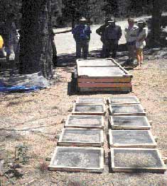
Seed drying in hand-made bins during summer From June until October of 1996, the Trinity County Resource Conservation District (RCD) conducted an extensive seed collection. The goal of the collection was to collect plants specific to the Grass Valley Creek (GVC) watershed in order to develop a seed bank to be drawn on over the next several years. Due to the uniquely harsh soil of the GVC watershed, and the need to keep plantings specific to site conditions, the RCD collected seed from plants growing only in the watershed. A large amount of native grasses, forbs, and shrubs were collected. The RCD began collecting seeds in 1994 with a conifer cone collection. After collection, the cones were sent off to be cleaned, processed, and stored. After cleaning, many of the conifer seeds were sent to nurseries for propagation--including Tsemta Forest Nursery in Hoopa and Humboldt Nursery in McKinnleyville. The resulting ponderosa, Jeffrey, and sugar pines, as well as incense cedar, were planted in the spring of 1996. Likewise, many of the shrub species--primarily ceanothus--have been sent off for propagation and will be planted in the fall of 1997 and/or the spring of 1998. Because grasses and shrubs are an important component of a recovering forest, the RCD has been supplementing conifer stock with many different species. Among those collected to be planted are species of manzanita, ceonothus, rabbittbrush, lupine, needlegrass, and fescue. In addition to having nurseries propagate plants, the RCD has created a mini-nursery of its own: in October, approximately 15,000 tubes with native grass seed, consisting of seven different species, were sown. Some of these plants will be ready for planting this spring, depending on the species, and in the future the RCD may grow forbs or shrubs. With a good stock of seeds in storage and a large amount of species planted, the RCD has made an investment that may create a healthier forest in the future.
Return to the Trinity County RCD Home Page
|