|
|
|
|
|
Contents
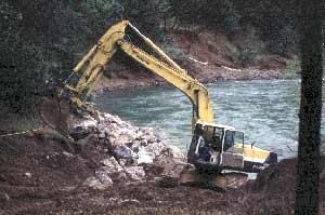
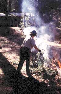
Coopers Bar EWPBy Jim Cooley,Administrative Assistant Private landowners, the RCD, and federal government agencies again teamed up to do important conservation work in our county. Homes in Coopers Bar were threatened by the Trinity River, which due to high flows was cutting into its banks and putting some homes in danger of falling into the river. Homeowners had begun to install rock on the banks, but the scale of the work needed was quickly outpacing their private resources.
Heavy equipment places large rocks along river bank These homeowners began their search for information on assistance at the local Office of Emergency Services (OES), a state agency which shares the County Sheriff’s office. The OES referred them to the RCD’s technical assistance partner, the Natural Resource Conservation Service (NRCS). The NRCS had already placed an advertisement notifying local landowners of available assistance programs for natural disasters. NRCS was also preparing to conduct a tour by the Federal Emergency Management Assessment Team (FEMAT) to assess the damage and assistance needs down river. As a result of the tour, the NRCS selected the Emergency Watershed Protection (EWP) as the appropriate program to help the landowners. The EWP was created to assist in disasters that threaten life or property. There were many steps to go through in a process like this. The RCD and NRCS worked closely to get it done. Structures were in danger from the constant erosion. First, the NRCS determined that the situation met the requirements of the program, among which was the fact that it was needed to assist a group with a common problem. As a result of this evaluation, the EWP response team from the state NRCS office was called in. On Friday of the week which the process started, the EWP team came and worked all weekend. A Damage Survey Report (DSR) was prepared by the NRCS and the EWP response team. The team also created the plan to put large “rip rap” rock along the river to stop the erosion. By Sunday a finished package was ready to send out for approval. The RCD was at work, too. Assistance programs require local agencies as sponsors. The role of sponsorship includes first getting information to landowners, then lining up their approval and participation. Sponsors are also responsible for securing permits needed. The RCD was able, from its experience with agencies, to quickly secure the local, state and federal permits. The permitting agencies used existing permits or special emergency waiver permits in order to respond to the emergency.
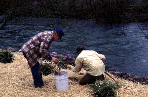
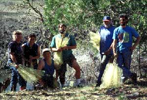
RCD Staff assist homeowners with replanting on Finally, sponsors are responsible to see to it that 25% matching funds are contributed. Neither the RCD or the County, regular sponsors in situations like this, had the funds for matching money. The RCD and NRCS innovated on this task, and found that money already spent by the landowners to save their land could be used as a match. This is a unique solution that local creativity and cooperation made possible. Bid packages were sent to local contractors on Monday of the next week, and a project showing was scheduled for that Tuesday. Bids were opened on Wednesday and the contract was awarded Thursday. Work was started on Friday, only a week after the process was begun. Local contractors told NRCS District Conservationist Jim Spear they “had never seen something move this fast.” Seven of the affected landowners joined the program, and some of their neighbors agreed to allow heavy equipment access through their property. The work was completed in two weeks. The RCD and the NRCS, working closely with appropriate local, state and federal agencies, swiftly put together a plan to assist county landowners in meeting the challenge presented by this event on the river. Homes were saved, funds were secured, and local people were given needed assistance. This is another example of how the local RCD can move quickly and coordinate with government agencies to creatively respond to the needs of county residents, bringing together government agencies and the people they are intended to serve. The NRCS is pursuing another EWP project with Trinity County as the sponsor this summer in Garden Gulch in Weaverville. The Board of Supervisors and affected landowners have approved this project. Hayfork Riparian Habitat Improvement ProjectBy Susan Garrett,Revegetation Coordinator The local Trinity County Resource Conservation District (RCD) and its partner, the federal Natural Resources Conservation Service (NRCS), have begun fisheries habitat improvement work in the South Fork of the Trinity River Basin. In March 1995, a crew of five local residents were hired to plant conifers and hardwood trees in various areas along Salt, Tule and Carr Creek in Hayfork Valley. Eighteen landowners agreed to participate in the Riparian Habitat Improvement Program, which was sponsored by the Trinity County Resource Conservation District in cooperation with the Natural Resources Conservation Service, and funded by the California Department of Fish and Game, Agricultural Stabilization and Conservation Service (ASCS), and the Trinity River Restoration Program. The purpose of this project was to enhance the riparian corridor for fish habitat, which we hope will eventually bring water temperatures down to an acceptable level for survival of steelhead and native fish populations, shade the creeks, and improve water quality for the Hayfork Valley. The work included riparian planting, scalping, tree seedling protection, fertilizing, enhancing rocky soils and installation of cattle exclusionary fencing.
RCD crews plant in riparian zone in Hayfork Valley. Prior to implementation of this project we observed various sections of Salt, Tule and Carr Creeks that had healthy riparian cover. The existing species of trees growing in the riparian corridors of Hayfork Valley include: willow, cottonwood, oak, alder, and conifers such as Ponderosa Pine, Grey Pine and Incense Cedar. Other species include: elderberry, chokecherry, and Birchleaf Mountain Mahogany. These were the conditions that we intended to move back towards through this work. Other areas were in poorer condition, either lacking in vegetation or choked with willows. The members of the local planting and fencing crew were: Janet Capes, Carolyn Rourke, Richard Christie Jay Sera and Randy Wilkinson, most of whom have been residents of the Hayfork area for over ten years. They planted 9,200 linear feet or approximately 5 acres of stream zone with: Bigleaf Maple, White Alder, Ponderosa Pine and Grey Pine -- a total of 2,675 trees, and they installed fence for a total of 2,300 linear feet of stream corridor protection. We intend to perform some maintenance work as required to keep these trees alive, with some weeding and/or watering as necessary. Employee Carolyn Rourke will monitor the effectiveness of the work by looking at success in establishment of tree cover and reduced water temperatures. An important component of the success of this project is in providing information and education in order to continue to acquire the support of additional landowners. The more people understand and agree to allow us to implement the work that we are doing on the ground, the more effective the work will be. This crew did an excellent job in this work and have assisted us in spreading the word to people in the area about the restoration work we are attempting to accomplish in the Hayfork Valley. All these efforts combined are helping to conserve and enhance natural resources for the private landowners, for the watershed and for the fisheries. At the same time the projects are spending money and hiring people locally which create benefits to the local economy. We believe that healthy, functioning riparian systems are compatible with other land uses, such as ranching and farming. It is our intent to work together with private landowners in the Hayfork Valley to develop management plans that meet landowner’s objectives as well as protect and enhance riparian systems. The RCD and NRCS have produced and submitted for approval four more grant proposals for funding. Three proposals were sent to California Fish and Game: one for riparian improvements on Carr Creek, another for Big Creek and a third for Salt Creek. Another proposal was submitted to US Fish and Wildlife Service for water conservation and stream stabilization work in the Hayfork Creek watershed. 1995 Spring Conservation TourBy Jim Cooley,Administrative Assistant
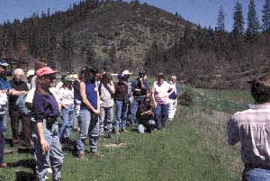
Jim Komar of the NRCS explains points of the water In the first half of the day, the tour visited sites in the Grass Valley Creek watershed, where the RCD is implementing erosion control measures as part of the Trinity River Restoration Program, whose goal is to restore wildlife and fish habitat in and along the river. Work in the watershed includes land recontouring and planting of bare slopes for erosion control. Also observed were test sites for vegetation and planting techniques. The second half of the day saw the tour going to Hayfork to Mr. and Mrs. Steve Beck’s ranch. The ranch is the site of a demonstration project for water conservation and riparian (stream side) improvement in the valley. The purpose of this work is to improve habitat for salmon fisheries in the South Fork of the Trinity River. Jim Komar, on staff with the Natural Resources Conservation Service, led the tour on a viewing of work on the Beck’s ranch. The tour visited an improved water diversion, an area of riparian planting, and an example of fencing to manage livestock access to a creek. Improved diversions conserve water and increase both the amount available for users and the amount that is left to flow in the river, which benefits fish habitat. Riparian planting can provide a shade canopy that keeps water temperatures “fish friendly”. Riparian fencing can manage livestock access to streams and conserve fish habitat. The Fall Conservation Tour is held in October. All residents of Trinity County and other interested parties are welcome. Contact the RCD office for more information at (916) 623-6004. AmeriCorps In The WatershedBy Jim Cooley, Administrative Assistantand Dana Sandifer, Project Coordinator The RCD would like to commend and acknowledge the hard work and cooperation of the Weaverville AmeriCorps members. While busy working on the Adopt A Watershed program, they also lent their hand when “people-power” was needed in the Grass Valley Creek watershed erosion work being implemented by the RCD. AmeriCorps members helped install willow wattles, which are tube shaped constructions made of sproutable willow branches. The tubes are anchored on steep hillsides and stream banks. Their purpose is to stop the downhill motion of soil on a bare bank in the short run, and in the long run be natural anchors for the soil on steep hillsides, as they sprout and root and become healthy vegetation. The AmeriCorps members also planted conifers and shrubs in February and March in the GVC watershed. AmeriCorps members are working for minimum wage, gathering experience in their chosen areas, and accumulating college tuition credits for use later. They are dedicating themselves to helping local communities, and in their work in Trinity County have made themselves available to many local projects and efforts. The RCD salutes them and their good work. Grass Valley Creek Coordinated Resource Management Plan (CRMP)By Steve Borchard,BLM Manager For the last 18 months, a group of private land owners, resource and recreation users and agency representatives have been working together to craft a Coordinated Resource Management Plan (CRMP) for the Grass Valley Creek watershed. Their efforts have blossomed into a comprehensive document which identifies major issues and recommends goals and actions which could be adopted by land managers in the watershed as a framework for future resource management. The idea behind the CRMP process is to identify and consider resource and social issues for an entire watershed area not just specific parcels in an area, involve anyone interested in the process, and "dissolve" the artificial property boundaries and work on issues and solutions on a watershed-wide basis. The CRMP document captures the discussions and recommendations of interested agencies, organizations and individuals regarding the future management of the Grass Valley Creek Watershed (GVC). Meetings and discussions were held to develop the concepts and model for a Coordinated Resource Management Plan. The group met several times to discuss issues of importance to private land owners, resource and recreation users, public land managers and as concerned citizens interested in the future of Trinity County and the watershed area. The issues included not only conditions or situations perceived as problems but situations that presented positive opportunities. The plan describes the major planning issues and opportunities, compiled from numerous GVC workshops and utilizes information from various studies and resource inventories. An attempt was made to prioritize the issues; this was an easy task when selecting the top priorities, but became less meaningful thereafter. Erosion and sedimentation is the most important issue in the watershed. The planning participants felt that erosion control and sediment reduction should over-ride all other priorities on public lands and most other priorities on private lands throughout the watershed. The first priority requires further discussion because of adamant support as the over-riding issue. 1. Erosion/Sedimentation the impacts of erosion in the watershed area and the impacts of sedimentation in the Trinity River elevate this issue to the top of the list. Sedimentation and other factors such as water diversion and river channel degradation have had a devastating impact on the anadromous fishery. Erosion can be subdivided into several categories for discussion and potential management. The sub-categories are: Erosion Control Philosophy, Road System Erosion, Off Highway Vehicle Erosion, Point Source Erosion and Sheet and Rill Erosion. 2. Private Property Rights private property owners are concerned with erosion control, recent acquisition and conversion from private to public ownership and future regulations and land uses on public lands. The sub-categories are: Rights, Trespass/Privacy, Timber Harvest and Land Management Assistance. 3. Public Land Management (public land means that managed by BLM only) with the recent conversion of 14,000 acres in the watershed from private to public ownership, concerns surrounding future uses and impacts on adjoining private parcels need to be discussed and carefully planned. The sub-categories are: Erosion/Sediment Reduction, Public Involvement, Vegetation/Fire Management, Recreation/Public Access, Reforestation and Timber Management. 4. Education the opportunities to contribute a public service through education are abundant. Current watershed restoration activities combined with keen public interest present the atmosphere for learning and communication. The sub-categories are: Erosion Control Technology Transfer, Adopt-a-Watershed, Interpretive Education. 5. Communications and Information Exchange with many different groups working in the watershed and keen interest apparent, a need for organized information exists to avoid misinformation. Suggested methods are the designation of a Central Clearinghouse and the publication of a Newsletter. Along with discussing issues and opportunities, the planning participants developed potential goals and steps to accomplish them. National Day of ServiceBy Jesse Miller,Regional Coordinator - Watershed Project April 25 marked the seventh annual National Day of Service. This significant day recognizes those that serve their community and aims to inspire others to also make a difference through service. The act of giving of one’s self for the betterment of the whole results in personal fulfillment and a strengthening of the ties that hold a community together.
AmeriCorps members doing fuels reduction The AmeriCorps Watershed Project and South Fork Coordinated Resource Management Planning (CRMP) group combined resources in order to encourage an ethic of service and increase awareness of fire protection. Phillus Lucas, a Hayfork senior and landowner, was concerned about the threat of fire spreading into or from her residence. Identified as a deserving/needy/qualifying landowner, her land was the site of the Salt Creek Fuels Reduction Demonstration Project. The project focused on eliminating both the vertical and horizontal continuity of vegetative fuels for the purpose of maintaining a 30 feet defensible space around the home. The Watershed Project service crew supplied the physical labor required for systematically reducing fuels. The crew had an energetic attitude towards service displayed by their productivity and quality of work. A chipper was provided by the Trinity County RCD to process the fuels into mulch. The mulch was then utilized for bank stabilization behind the home. Dave Lofler, Fire Marshall for the U.S. Forest Service, provided technical guidance throughout all stages of the project. Numerous CRMP members visited the site to show their support for landowner-directed (and ideally neighborhood-driven) fuels reduction projects. The National Day of Service Celebration truly brought diverse individuals together in the spirit of respect and cooperation. It is hoped that this spirit will inspire others to combine resources to find innovative solutions to stubborn problems. Spring 1995 PlantingIn Indian, Hoadley, and Grass Valley Creek WatershedsBy Sandra Dupret,Revegetation Coordinator The Trinity County Resource Conservation District (TCRCD) with some valuable help from AmeriCorps have had a record planting season this spring. In the previous two years of planting, each season between 50,000 and 90,000 plants and trees have been put in the ground. This spring, close to 112,000 plants were planted in seven weeks by eight TCRCD employees. Ten Weaverville AmeriCorps members assisted the RCD for four weeks. We planted in such sites as stream channel banks, sheet and rill, and areas that were treated with equipment last summer. This season it often took up to two hours one-way to get into some of the more remote areas. Because of the remoteness and inaccessibility of many of the planting sites, the help of pack animals was recruited. The animals saved both the backs of the crew members and the time required to transport plants to the site. This, along with the skill of the TCRCD planting crew, made the planting of these remote sites economically feasible and was responsible for the large number of plantings. The species planted included five different conifers; Ponderosa Pine, Jeffrey Pine, Douglas Fir, Sugar Pine and Gray Pine; three riparian trees: Big-Leaf Maple, White Alder and Black Willow; and five kinds of shrubs: Lemmon’s Ceanothus, Manzanita, Deer Brush, Red Bud, and Dwarf Ceanothus. A native grass, Blue Wildrye, was planted from plugs. These plants are chosen to match the zone, elevation, soil and other conditions that exist in this watershed. The Importance of Riparian ZonesBy Susan Garrett,Revegetation Coordinator Riparian areas are the green zone of vegetation between the water’s edge and the start of upland plants such as brush, grass or forest. Riparian zones are identified by the presence of vegetation that requires large amounts of free flowing water. Riparian areas are a very important part of the ecosystem. They provide food, shelter and cover for fish and wildlife. The root systems of riparian plants stabilize stream banks and provide flood control. The dense vegetation slows and filters water. An intact riparian zone acts as a filter between streams and agriculture. The functions of a healthy riparian system include: sediment filtering, bank stabilization, water storage and release, and aquifer recharge. Unfortunately, over previous decades many of these life-sustaining riparian areas have been developed, altered, and otherwise destroyed or neglected. So great is the decline that only 5-10 percent of the original riparian habitat in California still exists today, according to Douglas Wheeler, California Secretary of Resources. There are complex bonds between vegetation and streams. When vegetative cover is removed, soil erosion is increased. Streams become wider and shallower, heating up the water. Soil particles go into streams, settling and clogging the stream bed. The sediment reduces spawning habitat for fish and increases the chance of flood. Where the riparian zone has been removed, or scarcely exists, fertilizer and animal wastes can seep into streams and ground water. The shade of riparian trees provides many direct and indirect benefits to fish. Stream bank cover reduces erosion and sedimentation and controls the release of nutrients to the aquatic environment. Overhanging tree canopies maintain cool water temperatures and prevent loss of dissolved oxygen in the water. All riparian habitats have an exceptionally high value for many wildlife species. Such areas provide water, thermal cover, migration corridors and diverse nesting and feeding opportunities. The shape of many riparian zones, particularly the linear nature of streams, maximizes the development of an edge which is highly productive for wildlife. The range of wildlife that uses riparian habitat for food, cover and reproduction include amphibians, reptiles, birds and mammals. The riparian zone is especially valuable for many bird species. It is the richest breeding and wintering ground for birds in the Western United States. Thirty-five species of birds were identified that are dependent on riparian habitats. Other functions of riparian zones include windbreak, shade and control of emergent vegetation within the channel, aesthetics, and biodiversity in terms of species, as well as landscape diversity.
Return to the Trinity County RCD Home Page
|